Departure: Reykjavík, Iceland, September 20th 1999
Arrival: Reykjavík, Iceland, September 29th 1999
Svend-Aage Malmberg, Chief scientist
Jóhannes Briem, Physical oceanography, moorings
Steingrímur Jónsson, Physical oceanography, moorings
Héðinn Valdimarsson, Physical oceanography, moorings
John Mortensen, Physical oceanography
Magnús Danielsen, Chemical oceanography
Uwe Send, Physical oceanography, Univ. of Kiel
Andreas Pinck, Physical oceanography, Univ. of Kiel
Uwe Koy, Physical oceanography, Univ. of Kiel
The B13-99 cruise was carried out by the Marine Research Institute (MRI) on the RV Bjarni Sæmundsson with the following aims:
The RV Bjarni Sæmundsson left Reykjavík harbor at 2000 hours on September 20th 1999 for the B13-99 cruise.
The vessel headed for station 9 on the Faxaflói section and continued to the Látrabjarg section in the Denmark Strait where the first nine stations on the Icelandic side were occupied. The VEINS DS1 ADCP mooring was then successfully recovered and two ADCP moorings from the "Institut für Meereskunde", Univ. of Kiel, were deploy in the vicinity of the sill in the Denmark Strait. The ship then headed for the current meter mooring site IS6 on the Greenland side of the Kögur section. Along with the CTD-station work on the section VEINS moorings IS6 and IS7 were recovered routinely and attempts to recover VEINS mooring IS9 failed due to instrumental failure in the releaser. Dragging attempts were postponed for a later cruise due to limited ship time. After redeploying mooring IS7 and occupying a few more CTD-stations on the Kögur section the ship headed for the Hornbanki section. Here the VEINS mooring IS8 was successfully serviced and two additional moorings (H1 and H3) were deployed along with the CTD station work. The vessel then again headed for the Kögur section occupying the last three station of the section. The ship then called port at Isafjördur to set a scientist ashore. Meanwhile a low pressure system was passing the area delaying the departure by 10 hours on September 26th. At first chance the ship headed for a position where a thermistor chain from the "Institut für Meereskunde", Univ. of Kiel, was deployed and continued strait to mooring site DS1 on the Látrabjarg section where an ADCP was successfully redeployed. After occupying the remaining part of the Látrabjarg section towards Greenland the ship headed towards Reykjavík arriving at 1600 on September 29th 1999.
Both sections occupied in the Denmark Strait during the cruise are part of the VEINS programme. Locations of the sections are shown in Figure 1.
The hydrographic work was carried out with two independent CTD-water sampling units both equipped with Seabird Inc. SBE 911plus CTD´s. The first unit, a MRI made rosette equipped with 12 modified Hydro-Bios 1.7 liter water bottles and a General Oceanics underwater unit, was used for all standard CTD stations. The second unit (referred to as UNIT B), a SBE 32 rosette equipped with 12 Ocean Test Equipment Inc. 10 liter water samplers, was used for chemical sampling. Both units were equipped with newly calibrated temperature and conductivity sensors and water samples were collected at deepest sampling level on all stations for calibration purposes.
	    Temp. Calibr.  Cond. Calibr.
	   sensor date    sensor date

Unit A       2021 17-02-99  1643 19-02-99
Unit B        868 20-07-99   549 20-07-99
Samples for oxygen measurements were collected in 60 ml bottles,
and Winkler reagents added. Samples were then placed in a dark cold storage until the time of
analysis. Oxygen concentration was determined using a modified Winkler method.
Samples for nutrient analysis, nitrate, phosphate and silicate, were collected on selected
stations, in 250 ml polyethylene bottles. Samples were frozen, for later analysis in land
on a ChemLab auto-analyzer.
Samples for pCO2 and total carbonate were collected on 4 stations
in 500 and 250 ml bottles, preserved with mercury chloride and placed in cold storage.
Samples for delta carbon-13 were collected at 3 sites as full profiles.
The samples were preserved with mercury chloride.
Samples for oxygen-18 were collected at 3 sites as full profiles.
During the B13-99 cruise the following VEINS moorings were recovered and deployed (VEINS task 1.4.1, 1.4.3 and 1.4.4).
St. id.		Position    Water Instr. Type           Serial	Date	Notes
	Lat.	  Lon.	    depth depth			   no.
DS-1	66 04.87N 27 04.39W   650   643	 ADCP 75 KHz   	  1287	220999	recovered
DS-1	66 04.73N 27 04.97W   648   641	 ADCP 75 KHz   	  1287	270999	deployed
IS-6	68 07.31N 25 15.67W   814    80	 Aanderaa RCM7	 12315	230999	recovered
IS-6	68 07.31N 25 15.67W   814   500	 Aanderaa RCM7	  7332	230999	recovered
IS-6	68 07.31N 25 15.67W   814   764	 Aanderaa RCM7	 12560	230999	recovered
IS-9	67 56.12N 24 40.74W  1402    80	 Aanderaa RCM7	  8743	240999	rec. failed
IS-9	67 56.12N 24 40.74W  1402   300	 Aanderaa RCM7	 12316	240999	rec. failed
IS-9	67 56.12N 24 40.74W  1402  1350	 Aanderaa RCM7	 12559	240999	rec. failed
IS-7	67 32.04N 23 44.66W   819    80	 Aanderaa RCM7	 11987	240999	recovered
IS-7	67 32.04N 23 44.66W   819   300	 Aanderaa RCM7	  9976	240999	recovered
IS-7	67 32.04N 23 44.66W   819   750	 Aanderaa RCM7	 12317	240999	recovered
IS-7	67 32.93N 23 46.24W   850    80	 Aanderaa RCM7	 10858	240999	deployed
IS-7	67 32.93N 23 46.24W   850   300	 Aanderaa RCM7	 12305	240999	deployed
IS-7	67 32.93N 23 46.24W   850   750	 Aanderaa RCM7	 12654	240999	deployed
H-3	67 08.91N 21 19.89W   235    80	 Aanderaa RCM7	 11986	250999	deployed
H-3	67 08.91N 21 19.89W   235   150	 Aanderaa RCM7	 12634	250999	deployed
IS-8	67 00.00N 21 34.00W   199    79	 Aanderaa RCM7	  8285	250999	recovered
IS-8	67 00.00N 21 34.00W   199   154	 Aanderaa RCM7	  9977	250999	recovered
H-2	67 00.11N 21 33.63W   201    80	 Aanderaa RCM7	 12314	250999	deployed
H-2	67 00.11N 21 33.63W   201   150	 Aanderaa RCM7	 12308	250999	deployed
H-1	66 53.88N 21 24.79W   140    80	 Aanderaa RCM7	 12306	250999	deployed
Most of the goals of the cruise were achieved (see list of stations and cruise track-Figure 1) except for the failure not recovering the one year-long current meter mooring IS9 on the Kögur section. Dragging attempts had to be postponed to another cruise due to lack of time.
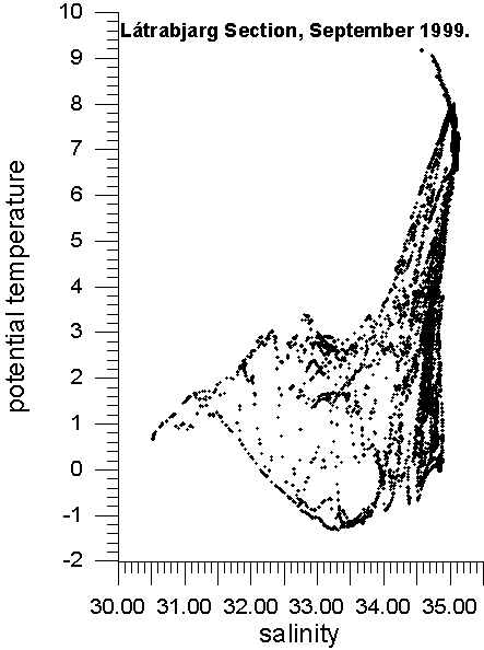
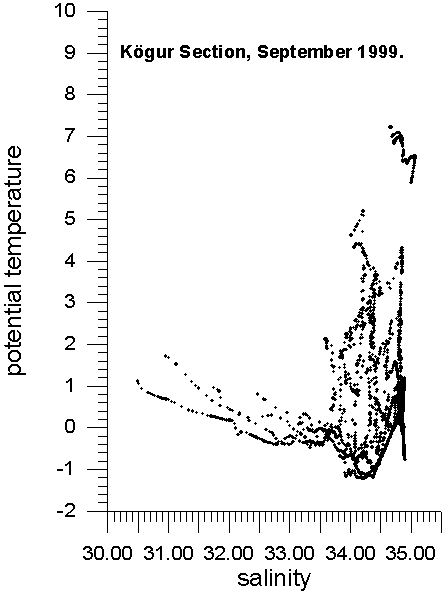
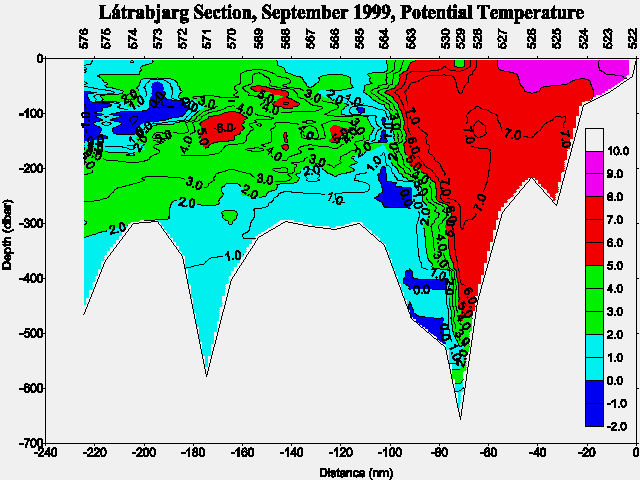
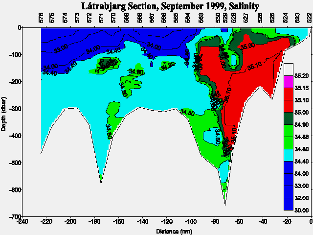
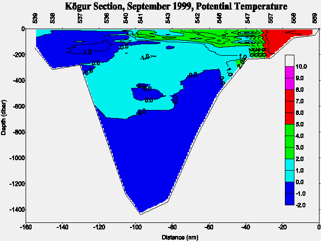
Preliminary inspection of the CTD data showed still relatively high salinities and temperatures in the flow of Atlantic water on the Látrabjarg section as in September 1997 and 1998 but less so in the Kögur section. In the East Greenland Current the temperature and salinity was not as low as in September 1997 and 1998 in accordance with that no drift ice was observed in the survey area during this cruise.
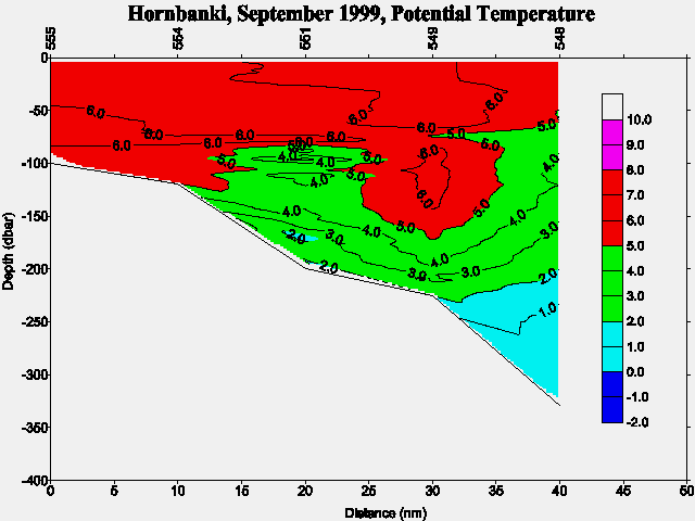
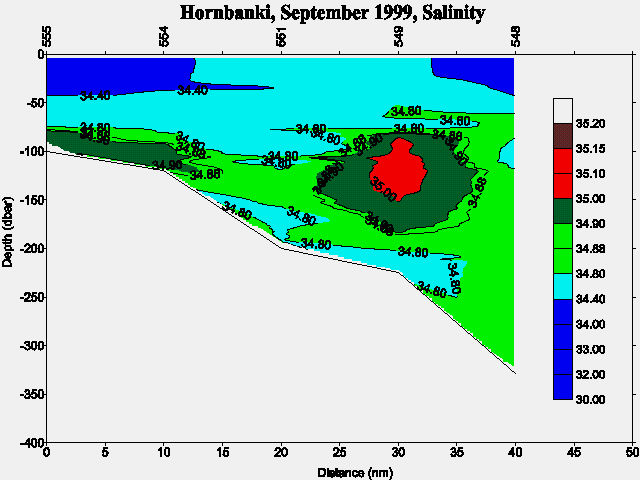
Preliminary TS-diagrams from the Látrabjarg and Kögur sections show the results above. In addition are preliminary potential temperature and salinity sections shown for Látrabjarg (Fig. 3a and Fig. 3b), Kögur (Fig. 4a and Fig. 4b) and Hornbanki (Fig. 4a and Fig. 4b) sections respectively, of which the first two are part of the VEINS programme. For location of the above sections and mooring sites see Figure 1.
In case of further information contact:
| Svend-Aage Malmberg | Email: | svam@hafro.is |
| Jóhannes Briem | Email: | briem@hafro.is |
| Héðinn Valdimarsson | Email: | hv@hafro.is |
| John Mortensen | Email: | johnm@hafro.is |
or by mail:
Att. nameor
Tel. (+354) 55 20240
Fax. (+354) 56 23790
| © MRI | Back to Cruise Reports | ||
|
|
|||
| Responsible: John Mortensen | MRI | ||