Departure: Reykjavík, Iceland, May 7th 1998
Arrival: Reykjavík, Iceland, May 23th 1998
Þorsteinn Sigurðsson, Chief scientist
Ingi Lárusson, Captain
John Mortensen, Physical Oceanography
Páll Reynisson, Physical Oceanography, Redfish
Þorgrímur Baldursson, Redfish
Þórður Viðarsson, Redfish
Ásgeir Gunnarsson, Redfish
Einar Ásgeirsson, Redfish
Klara B. Jakobsdóttir, Redfish
The B05-98 cruise was carried out by the Marine Research Institute (MRI) on the RV Bjarni Sæmundsson with the following hydrographic aims:
The RV Bjarni Sæmundsson left Reykjavík harbor at 2000 hours on May 7nd 1998 for the B05-98 cruise. Two drifters were deployed and 23 CTD stations were occupied during the 16 days cruise. The CTD stations were divided into 3 main sections along 60 00N, 61 25 and 62 35N respectively. A single station 62 00N, 32 30W was occupied due to historical reasoning. After 2138 nautical miles the ship arrived Reykjavík harbor at 1000 hours on May 23nd 1998.
The hydrographic work was carried out with a CTD-water sampling unit equipped with a Seabird Inc. SBE 911plus CTD's. The unit, a MRI made rosette equipped with modified Hydro-Bios 1.7 liter water bottles and a General Oceanics underwater unit, was used for all standard CTD stations. A Sea-Tec transmissometer was attached to the MRI unit. The CTD unit were equipped with newly calibrated temperature and conductivity sensors and water samples were collected at deepest sampling level on all stations for calibration purposes.
	    Temp. Calibr.  Cond. Calibr.
	   sensor date    sensor date

Unit A       2021 22-01-98  1643 16-01-98
The main results of the hydrographic observations (see list of stations and cruise track-Figure 1), covering the upper 1000 m of the water column in the adjacent waters to the Reykjanes Ridge (i.e. the Irminger Sea and Iceland Basin) in May 1998 were the following (see e.g. Fig. 2a, Fig. 2b, Fig. 3a, Fig. 3b, Fig. 4a, and Fig. 4b).
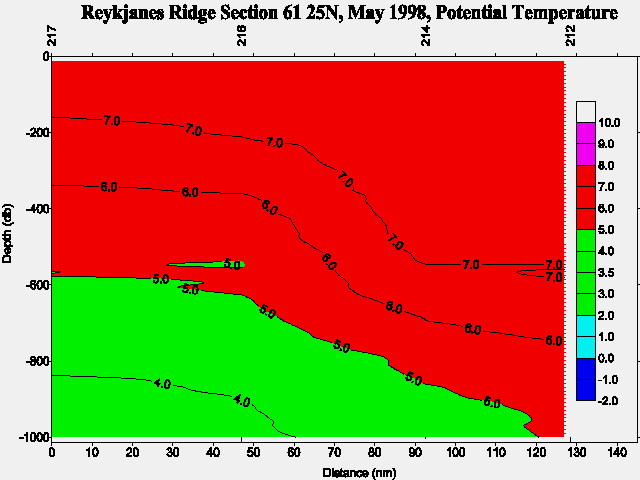
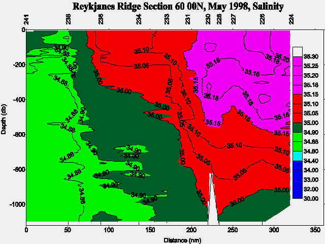
The Atlantic Water or more precisely the Modified North Atlantic Water (MNAW), observed at almost all stations, showed high temperature (6-8ºC) and salinities (up to and above 35.2). The salinities being in accordance with earlier Icelandic observations south and west of Iceland in year 1997 and beginning of 1998 which were higher than during previous years. No seasonal thermocline had yet developed due to the time of season of the cruise, it is therefore believed that the surface temperatures will be higher in the area latter this summer than previous years. The highest temperatures and salinities were found east (in the Iceland Basin) and over the Reykjanes Ridge, with a general decrease especially in salinity (~0.10psu) towards the west in the Irminger Sea. Only very few stations showed water with temperature less than 3.5ºC and these were all situated in the southern central part of the Irminger Sea below 600 m depth ( Figure 4a). Two frontal zones were observed between the two above mentioned water masses along the 60 N section (Figure 4a and Figure 4b). ). The first was observed between station 238 and 236 at the surface in the central part of the Irminger Sea and the second between station 233 and 231 in the depth range 200 m to 1000 m just west of the Reykjanes Ridge. In connection to the latter front evidence of strong mixing was observed in the depth range 300 m to 800 m.
Click your way through the cruise track , i.e. by clicking in the left or right part of the section name you will get potential temperature or salinity sections of the section respectively.
Compared with newer and historical hydrographic data from the area (1955, 1958, 1959 and 1988) the
extension of the 35.10 isohaline to the west have never, with respect on the years just mentioned, been
observed so westerly as now (Dietrich 1957, Anon. 1960, Anon. 1961, Krauss 1995).
Anon., Annales Biologiques, 1958, Vol. XV, 233 pp., 1960.
Anon., Annales Biologiques, 1959, Vol. XVI, 261 pp., 1961.
Dietrich, G., Schichtung und Zirkulation der Irminger-See im Juni 1955, Ber. Dtsch. Wiss. Komm. Meeresforsch., 14(4), 255-312, 1957.
Krauss, W., Currents and mixing in the Irminger Sea and in the Iceland Basin, J. Geophys. Res., 100(C6), 10851-10871, 1995.
In case of further information contact:
| Dr. Svend-Aage Malmberg | Email: | svam@hafro.is |
| Mr. Héðinn Valdimarsson | Email: | hv@hafro.is |
| Dr. John Mortensen | Email: | johnm@hafro.is |
or by mail:
Att. nameor
Tel. (+354) 55 20240
Fax. (+354) 56 23790
| © MRI | Back to Cruise Reports | ||
|
|
|||
| Responsible: John Mortensen | MRI | ||