Departure: Reykjavík, Iceland, February 16th 2000
Arrival: Reykjavík, Iceland, March 4th 2000
Svend-Aage Malmberg, Chief scientist
Jóhannes Briem, Physical oceanography and moorings
Héðinn Valdimarsson, Physical oceanography
John Mortensen, Physical oceanography
Magnús Danielsen, Physical and Chemical oceanography
Björn Sigurðarsson, Capelin
Jörg Reppin, Physical oceanography, Univ. of Kiel
Andreas Macrander, Physical oceanography, Univ. of Kiel
The B02-2000 cruise was carried out by the Marine Research Institute (MRI) on the RV Bjarni Sæmundsson with the following aims:
The RV Bjarni Sæmundsson left Reykjavík harbor at 2000 hours on February 16th 2000 for the B02-00 cruise.
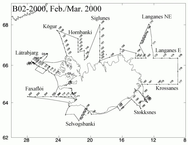
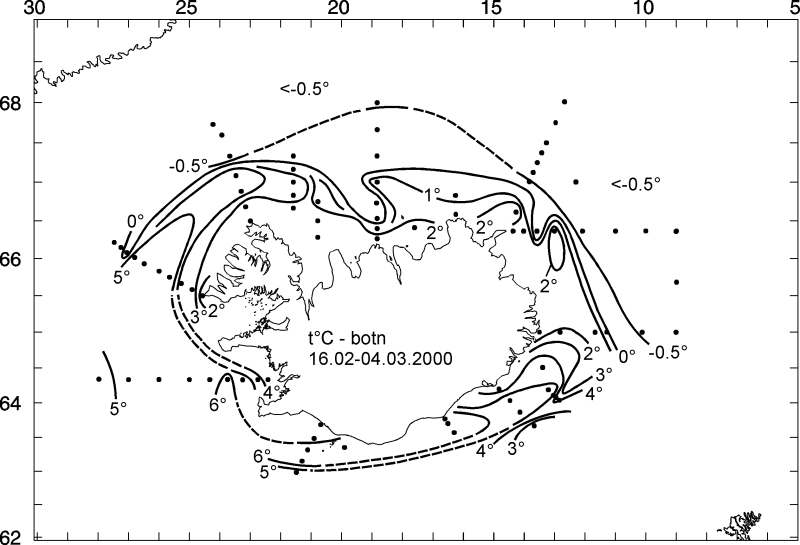
The vessel headed for the Faxaflói section ( Figure 1) just carrying out 5 stations due to weather, and then heading for the Látrabjarg section with 10 hydrographic stations. The next day (18.02) 5 different moorings in the Denmark Strait sill area were recovered (3 ADCP's, an inverted echo-sounder and a TS-chain). After some capelin investigations port was sought in Isafjörður due to bad weather. The ship then occupied the Kögur, Hornbanki, Húnaflói and Siglunes sections and ported in Siglufjörður (22.02). From there the ship headed for the Melrakkaslétta, Langanes NE, Langanes E and Krossanes sections (23.-26.02). Shelter was sought in Berufjörður (27.-29.02) due to bad weather, after that the vessel headed for Stokksnes, Ingólfhöfði and Selvogsbanki sections and the last stations on the Faxaflói section (st. 5-9) left over at the beginning of the cruise. After 16 days the RV arrived in Reykjavík at 0900 hours on March 3th 2000.
The hydrographic work was carried out with two independent CTD-water sampling units both equipped with Seabird Inc. SBE 911plus CTD´s. The first unit, a MRI made rosette equipped with 12 modified Hydro-Bios 1.7 liter water bottles and a General Oceanics underwater unit, was used for all standard CTD stations. The second unit (referred to as UNIT B), a SBE 32 rosette equipped with 12 Ocean Test Equipment Inc. 10 liter water samplers, was used for chemical sampling. Both units made use of the same pair of newly calibrated temperature and conductivity sensors and water samples were collected at deepest sampling level on all stations for calibration purposes.
                Temp.     Calibr.    Cond.      Calibr.     Pres.
	        sensor    date       sensor     date        sensor

Unit A		 2021     01-02-00    1643      01-02-00    35944
Unit B		 2021     01-02-00    1643      01-02-00    44079
sensor set II     868     29-01-00     549      01-02-00    35944
Samples for oxygen measurements were collected in 60 ml bottles,
and Winkler reagents added. Samples were then placed in a dark cold storage until the time of
analysis. Oxygen concentration was determined using a modified Winkler method.
Samples for nutrient analysis, nitrate, phosphate and silicate, were collected on selected
stations, in 250 ml polyethylene bottles. Samples were freezed, for later analysis in land
on a ChemLab auto-analyzer.
Samples for pCO2 and total carbonate were collected on 2 stations
in 500 and 250 ml bottles, preserved with mercury chloride and placed in cold storage.
Samples for delta carbon-13 were collected at 2 site. The samples were preserved with mercury chloride.
During the B02-00 cruise the following Icelandic current meter mooring was recovered.
St.id.	     Position       Water Instr. Type           Serial  Date    Notes
	Lat.	  Lon.	    depth depth			no.
DS-1	66 04.73N 27 04.97W  648   641	 ADCP 75 KHz    1287	180200  recovered
All of the goals of the cruise were achieved (see list of stations and cruise track-Figure 1). Five moorings were recovered in the Denmark Strait area, whereas a number of redfish trawls had to be canceled due to rather harsh weather conditions.
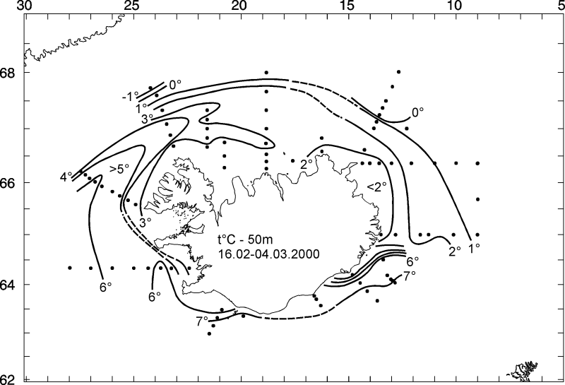
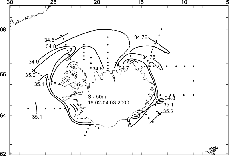
The main results of the hydrographic conditions in Icelandic waters in February 2000 were the following (see e.g. Fig. 13a , Fig. 13b , and Fig. 14 ):
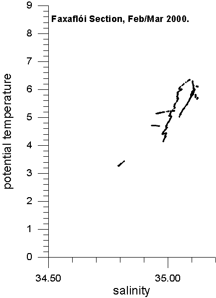
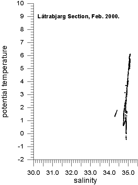
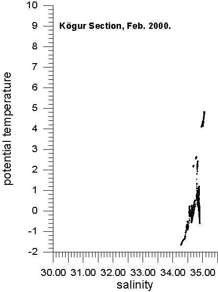
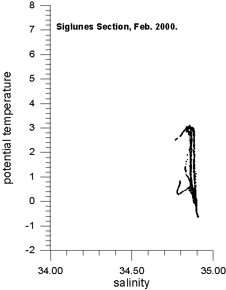
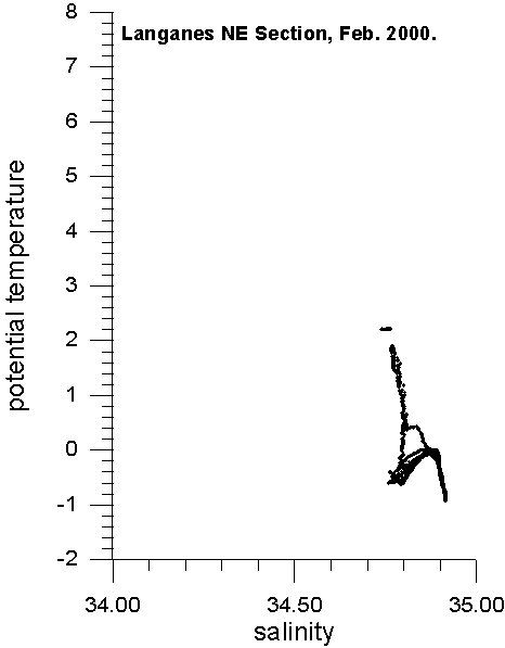
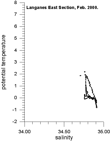
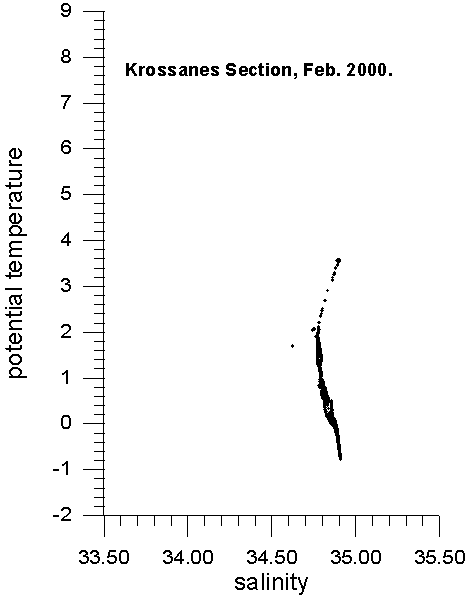
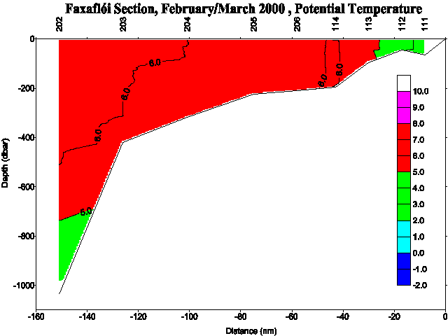
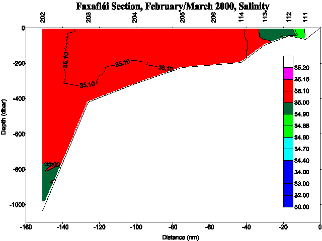
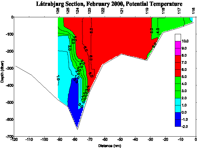
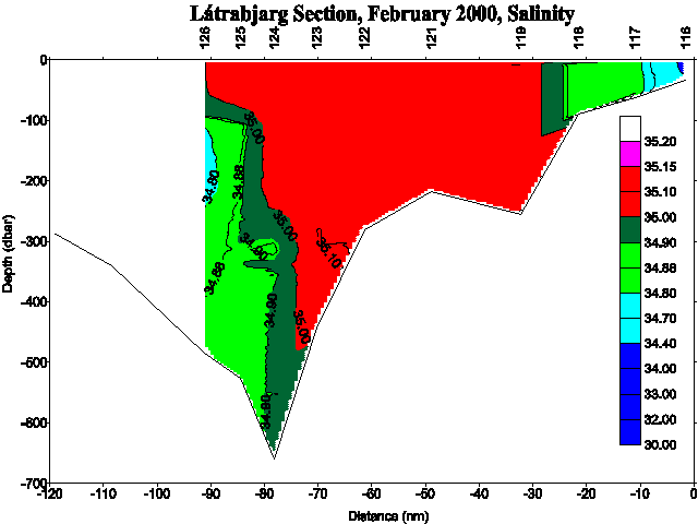
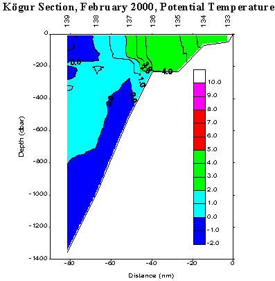
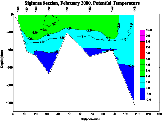
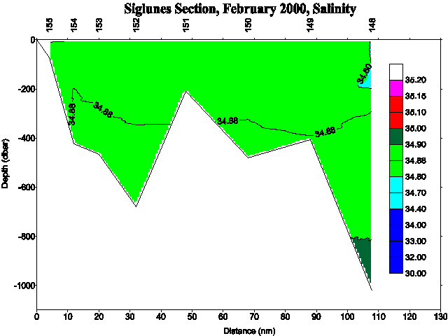
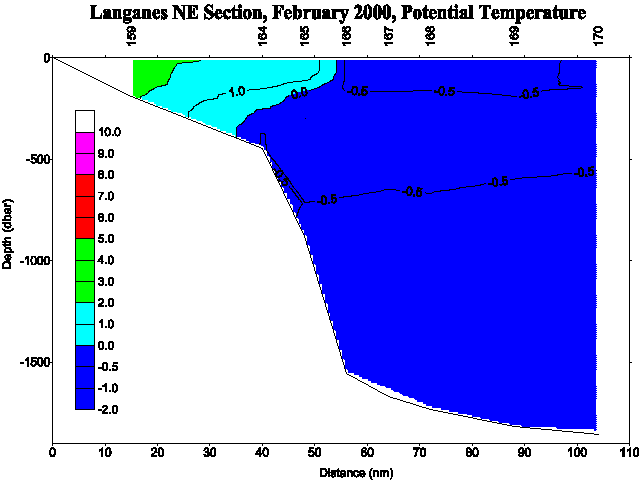
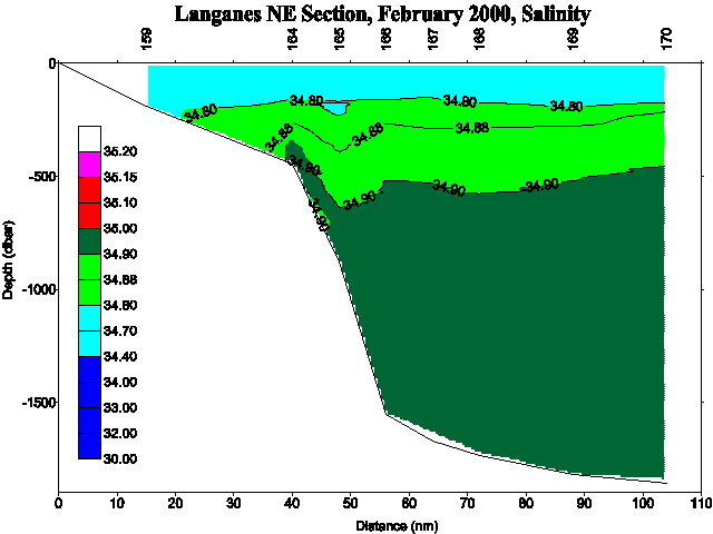
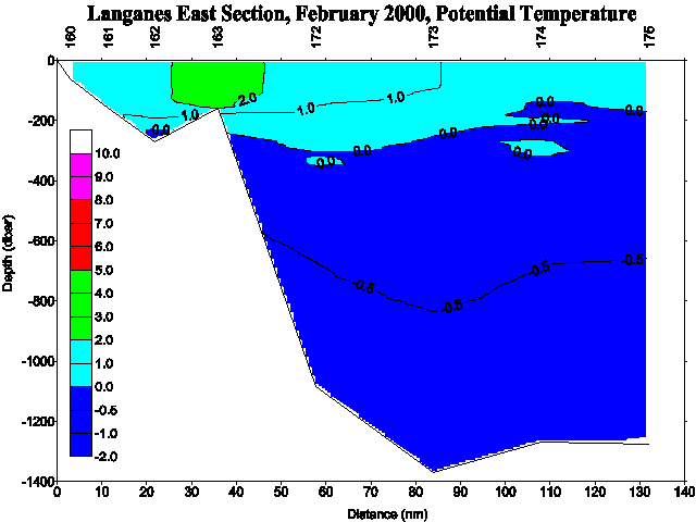
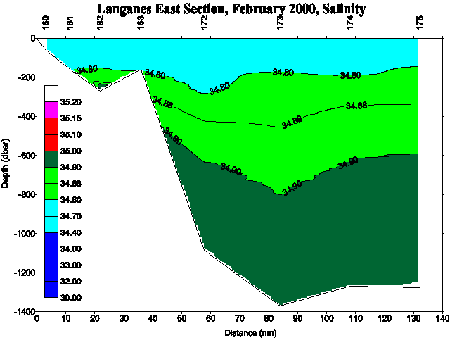
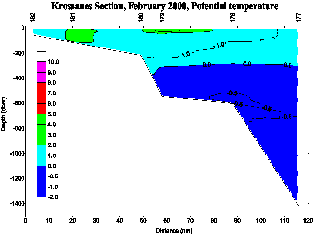
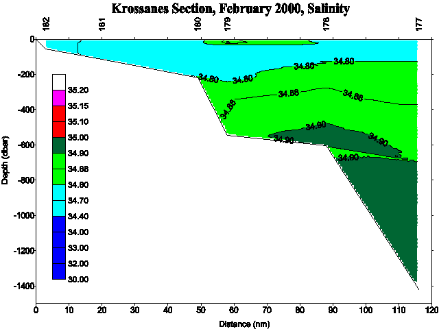
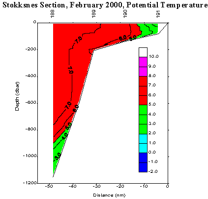
Atlantic Water south and west of Iceland showed relatively high temperatures (6-7°C) and salinities (35.00-35.20), the high salinities still being in accordance with those since 1997 which were higher than during the years before or even since the sixties-seventies. Temperatures of 4-6°C and salinities above 35.00 were observed in the Denmark Strait area off the NW peninsula and no drift-ice was observed. The Atlantic inflow into North Icelandic waters influenced the waters eastward to the Siglunes section (3-4°C, 34.80-34.90) where in general "North Icelandic Winter Water" was found (2-3°C, ~34.80), extending relatively far to the north and east. Thus the cold water from the north was found far off and no drift-ice was observed. Off the East coast temperature and salinity were 1-2°C and above 34.7 respectively, and the cold East Icelandic Current was far-off and moderate in characteristics with increasing temperatures and salinities since August 1999 (>0°C, almost 34.8).
Thus the hydrographic conditions in Icelandic waters in February 2000 were in general quite favorable, even more favorable than during previous winters. The results may even be compared with those from before the so-called ice years in the sixties.
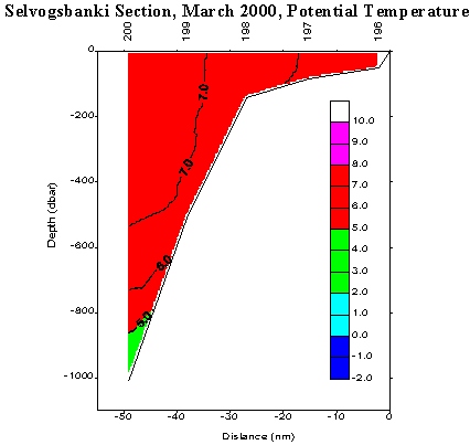
Preliminary TS-diagrams from the Faxaflói , Látrabjarg , Kögur , Siglunes , Langanes NE , Langanes E , Krossanes , Stokksnes and Selvogsbanki sections show the results above. In addition are preliminary potential temperature and salinity sections shown for Faxaflói (Fig. 3a and Fig. 3b), Látrabjarg (Fig. 4a and Fig. 4b), Kögur (Fig. 5a and Fig. 5b), Siglunes (Fig. 6a and Fig. 6b), Langanes NE (Fig. 7a and Fig. 7b), Langanes E (Fig. 8a and Fig. 8b), Krossanes (Fig. 9a and Fig. 9b), Stokksnes (Fig. 10a and Fig. 10b) and Selvogsbanki (Fig. 11a and Fig. 11b) sections respectively.
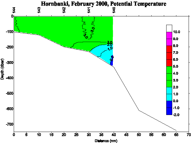
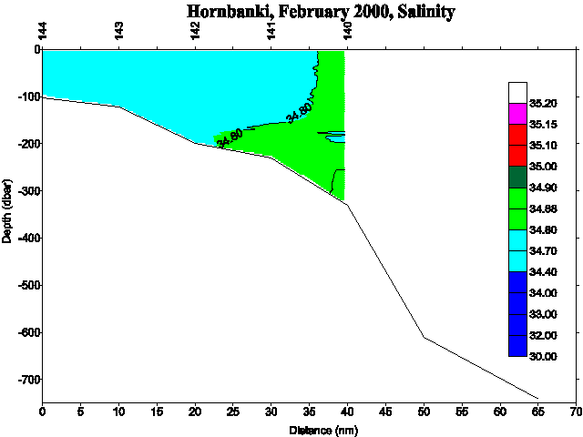
Another potential temperature and salinity sections have been included in this report showing the Hornbanki Section (Mooring Section IS8) (Fig. 12a and Fig. 12b). For location of the above sections see Figure 1 and the station numbers.
In case of further information contact:
| Svend-Aage Malmberg | Email: | svam@hafro.is |
| Jóhannes Briem | Email: | briem@hafro.is |
| Héðinn Valdimarsson | Email: | hv@hafro.is |
| John Mortensen | Email: | johnm@hafro.is |
or by mail:
Att. nameor
Tel. (+354) 55 20240
Fax. (+354) 56 23790
| © MRI | Back to Cruise Reports | ||
|
|
|||
| Responsible: John Mortensen | MRI | ||