Departure: Reykjavík, Iceland, November 10th 1999
Arrival: Reykjavík, Iceland, December 8th 1999
Jóhannes Briem, Chief scientist
Héðinn Valdimarsson, Physical oceanography
John Mortensen, Physical oceanography
Magnús Danielsen, Physical and chemical oceanography
Hjálmar Vilhjálmsson, Capelin
Björn Sigurðarsson, Capelin
Sigurður Gunnarsson, Capelin
The B16-99 cruise was carried out by the Marine Research Institute (MRI) on the RV Bjarni Sæmundsson with the following aims:
The RV Bjarni Sæmundsson left Reykjavík harbor at 2000 hours on November 10th 1999 for the B16-99 cruise.
The vessel headed for the Faxaflói section ( Fig. 1) completing all twenty stations before proceeding to the Látrabjarg section where ten stations were occupied before ice hindered further progress. Near to station 9 on the Látrabjarg section an inverted echosounder (PIES) was deployed for the IFM Kiel.
After calling at Isafjörður to pick up two capelin biologists a course was set for the Kögur section, the cruise now being a combined hydro-capelin survey.
Just before reaching the third CTD-station at Kögur the ship came to the ice edge. After making a CTD cast the ship sailed east along the ice edge for a few miles before heading for the Hornbanki section. A lead west into the ice around 67°15'N made it possible to search the area for capelin for the next two days but a storm on the 19th forced the ship to take a 48 hour refuge in Siglufjörður. At midday on the 21st the storm had receded enough for work to continue and in the next three days the area between 18°50'W and 16°15'W was surveyed before the next storm interrupted work. This time shelter was sought in Seyðisfjörður.
After a delay of two and a half days work continued east along the Krossanes section after which the area up to the Langanes East section was surveyed for capelin.
On the 30th the ship proceeded along the Langanes NE section in heavy weather and after having to spend several hours riding out the storm the last station at 68°N was completed around noon on the 1st of December. Thereafter the area between the Langanes East and Northeast was searched for capelin with little success and a course was set northwest along the shelf edge. Around 0800 on the 2nd of December work had to abandoned once again due to a new storm. A course was set due west for Isafjörður but in view of increasing wind it was decided to head for Skagafjörður and the harbor of Sauðárkrókur.
At midnight on the 3rd the storm had passed and the capelin survey in the Denmark Strait could be continued until at noon on the 5th when a new storm hindered work once again. This time refuge was sought in Isafjörður. On the morning of the 7th the weather forecasts for the next 5 days was for a continued storm it was decided to head for home and at 1300 hours the ship left Isafjörður in a northeasterly gale and headed for Reykjavik arriving there at 1900 hours on December 8th.
Sections confined to VEINS are those of Faxaflói, Látrabjarg, Kögur, Langanes NE and Krossanes. Locations of hydrographic sections are shown in Figure 1.
The hydrographic work was carried out with two independent CTD-water sampling units both equipped with Seabird Inc. SBE 911plus CTD´s. The first unit, a MRI made rosette equipped with 12 modified Hydro-Bios 1.7 liter water bottles and a General Oceanics underwater unit, was used for all standard CTD stations. The second unit (referred to as UNIT B), a SBE 32 rosette equipped with 12 Ocean Test Equipment Inc. 10 liter water samplers, was used for chemical sampling. Both units made use of the same pair of newly calibrated temperature and conductivity sensors and water samples were collected at deepest sampling level on all stations for calibration purposes.
	    Temp. Calibr.  Cond. Calibr.
	   sensor date    sensor date

Unit A       1428 31-08-99  1162 31-08-99
Unit B       1428 31-08-99  1162 31-08-99
Samples for oxygen measurements were collected in 60 ml bottles,
and Winkler reagents added. Samples were then placed in a dark cold storage until the time of
analysis. Oxygen concentration was determined using a modified Winkler method.
Samples for nutrient analysis, nitrate, phosphate and silicate, were collected on selected
stations, in 250 ml polyethylene bottles. Samples were frozen, for later analysis in land
on a ChemLab auto-analyzer.
Samples for pCO2 and total carbonate were collected on 3 stations
in 500 and 250 ml bottles, preserved with mercury chloride and placed in cold storage.
Samples for delta carbon-13 were collected at 1 site as a full profile.
The samples were preserved with mercury chloride.
Samples for oxygen-18 were collected at 1 site as a full profile.
Nearly all of the goals of the cruise were achieved (see list of stations and cruise track-Figure 1) except the sections south of Iceland.
The hydrographic conditions in Icelandic waters in November 1999 were as follows:
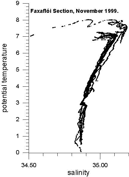
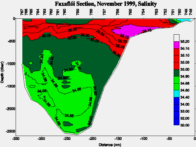
West of Iceland the Atlantic Water of the Irminger Current still shows relatively high temperature (6-8°C) and salinity (>35.15) which is a continuation of the condition observed since 1997. However, compared with the November cruise in 1998 a slight decrease can be observed in both temperature and salinity in the Atlantic Water on the Faxaflói section.
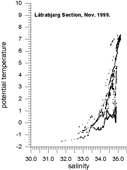
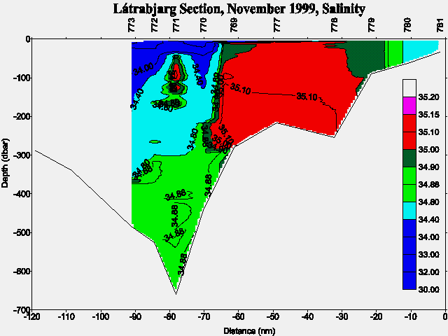
In the Denmark Strait (Látrabjarg section) Atlantic Water was found on the Icelandic continental shelf with out-flowing overflow water occupying the deeper parts of the Strait.
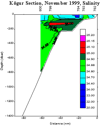
Due to prevailing southerly winds before and during the first part of the cruise most of the central part of the Denmark Strait was inaccessible due to heavy ice concentration with the ice-limit only about 20 nautical miles off the coast at Kögur.
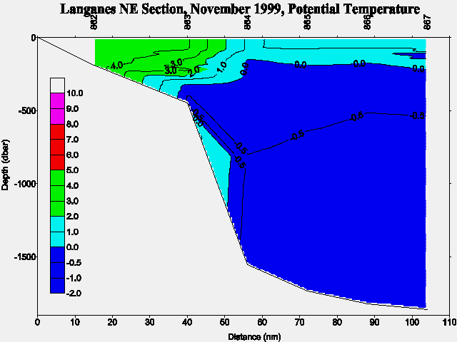
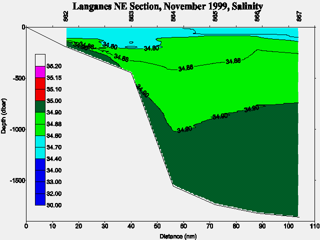
The inflow of Atlantic Water into the North Icelandic shelf was observed to be quite pronounced and could be traced as far east as the Langanes Northeast section. The low saline surface layer which has been occupying large areas north of Iceland during previous years was now observed to be replaced by diluted Atlantic Water (T>4°C, S>34.8) and only found in the outer reaches of the survey area.
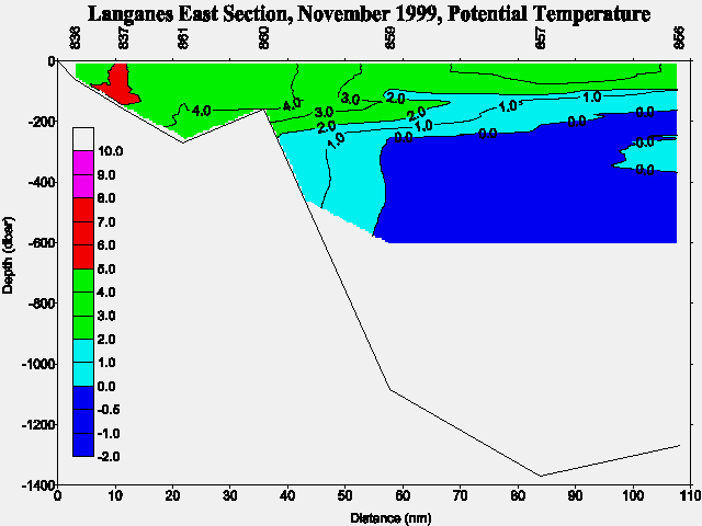
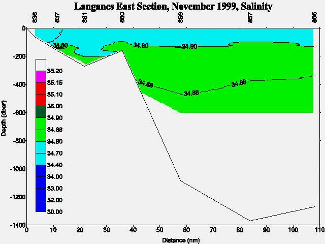
Northeast and east of Iceland temperature and salinity were generally higher (T>4°C, S>34.7) than during November 1998. The cold East Icelandic Current was observed relatively far off the coast with temperature above 1°C and salinity around and slightly above 34.7.
The main point of interest for the VEINS project from the November 1999 investigation is that high temperature and salinity was still found in the Irminger Current west of Iceland and continued as a relatively widespread inflow into the North Icelandic shelf area. The fresh water component of the East Icelandic Current was weak and only found in the northeastern corner of the survey area, far off the coast.
During the cruise the coldest overflow water values ever experienced during the Icelandic VEINS program were observed at 2200m depth in a ca. 10m thick layer above the bottom with the properties of 0.03°C (potential temp.) and 34.865. This water mass was also observed just south of the sill in Denmark Strait (the Látrabjarg section) suggesting only a minor entrainment of ambient waters into this thin homogeneous bottom layer. Notice, that no conclusion about trends of the overflow layer should be drawn from this single observation.
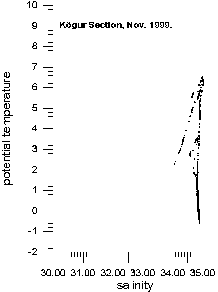
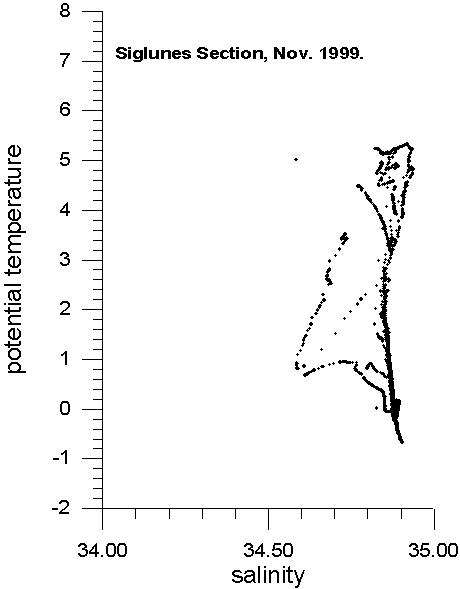
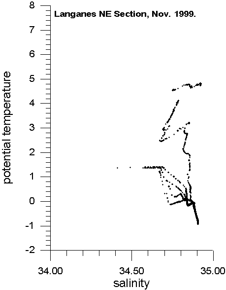
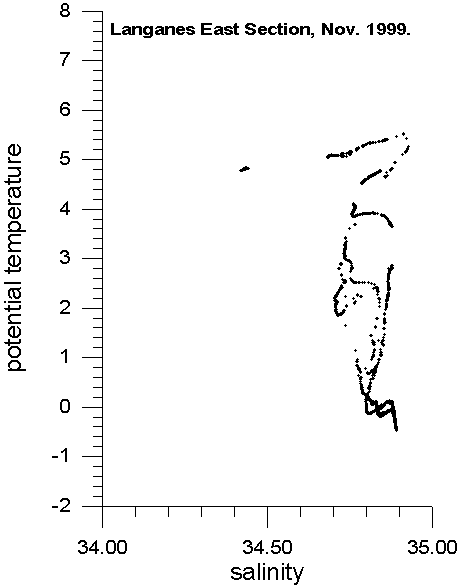
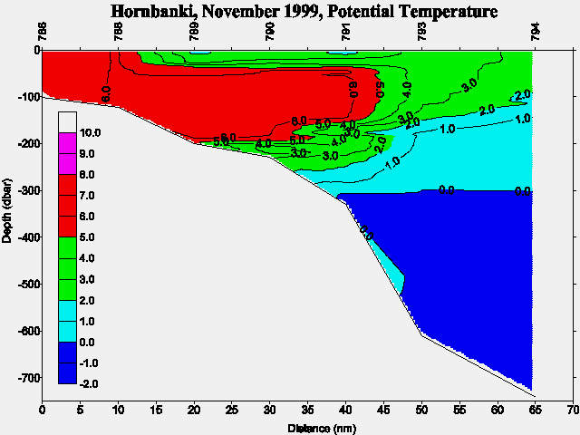
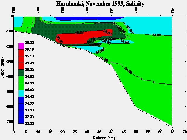
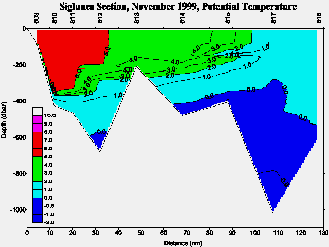
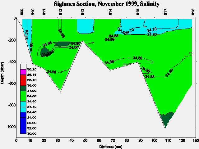
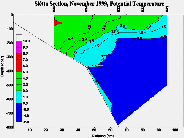
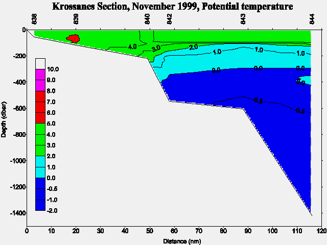
Preliminary TS-diagrams from the Faxaflói , Látrabjarg , Kögur , Siglunes , Langanes NE , Langanes E , and Krossanes sections show the results above. In addition are preliminary potential temperature and salinity sections shown for Faxaflói (Fig. 3a and Fig. 3b), Látrabjarg (Fig. 4a and Fig. 4b), Kögur (Fig. 5a and Fig. 5b), Hornbanki (Fig. 6a and Fig. 6b), Siglunes (Fig. 7a and Fig. 7b), Slétta (Fig. 8a and Fig. 8b), Langanes NE (Fig. 9a and Fig. 9b), Langanes E (Fig. 10a and Fig. 10b), and Krossanes (Fig. 11a and Fig. 11b) sections respectively, of which Figure 3, 4, 5, 9 and 11 are part of the VEINS programme. For location of the above sections see Figure 1.
In case of further information contact:
| Jóhannes Briem | Email: | briem@hafro.is |
| Héðinn Valdimarsson | Email: | hv@hafro.is |
| John Mortensen | Email: | johnm@hafro.is |
| Svend-Aage Malmberg | Email: | svam@hafro.is |
or by mail:
Att. nameor
Tel. (+354) 55 20240
Fax. (+354) 56 23790
| © MRI | Back to Cruise Reports | ||
|
|
|||
| Responsible: John Mortensen | MRI | ||