Departure: Reykjavík, Iceland, May 26th 1998
Arrival: Reykjavík, Iceland, June 16th 1998
Ólafur Ástthórsson, Chief scientist
Héðinn Valdimarsson, Physical Oceanography
Svend-Aage Malmberg, Physical Oceanography
Jóhannes Briem, Physical Oceanography, moorings
Steingrímur Jónsson, Physical Oceanography, moorings
Magnús Danielsen, Chemical Oceanography
Jón Ólafsson, Chemical Oceanography
Ása Kristjansdóttir, Chemical Oceanography
Kristinn Gudmundsson, Phytoplankton
Kristín Valsdóttir, Phytoplankton
Agnes Eydal, Phytoplankton
Ástþór Gíslason, Zooplankton
Kjartan Kjartansson, Zooplankton
Dorinda R. Ostermann, Sediments traps, Woods Hole Inst., USA
The B06-98 cruise was carried out by the Marine Research Institute (MRI) on the RV Bjarni Sæmundsson with the following aims:
The RV Bjarni Sæmundsson left Reykjavík harbor at 2000 hours on the 26th of May 1998 for the B06-98 cruise.
The vessel headed for the Faxaflói section towards East Greenland, from there to the Látrabjarg and Kögur sections in the Denmark Strait, where drift-ice was hampering the work and not all the standard stations could be reached. From here the vessel headed eastwards into North Icelandic waters through the mooring IS8, where a VEINS current meter mooring was serviced; further through the Húnaflói, Siglunes, Langanes NE, Langanes E and Krossanes sections, servicing 4 VEINS current meter moorings in the East Icelandic Current. The area east of the usual survey area east of Iceland was also investigated to 6°W to look for migration of Atlanto-Scandian Herring. From there the vessel headed for the Stokksnes, Ingólfhöfði and Selvogsbanki sections and arrived to Reykjavik at 0800 hour on the 16th of June.
Sections confined to VEINS are those of Faxaflói, Látrabjarg, Kögur, Langanes NE and Krossanes. Locations of hydrographic sections and current meter moorings (IS8, LNA1, LNA2, KR4 and KR6, indicated by m, VEINS task 1.4.3 and 1.4.4) are shown in Figure 1.
The hydrographic work was carried out with two independent CTD-water sampling units both equipped with Seabird Inc. SBE 911plus CTD's. The first unit, a MRI made rosette equipped with 12 modified Hydro-Bios 1.7 liter water bottles and a General Oceanics underwater unit, was used for all standard CTD stations. The other unit (referred to as Unit B) comprised of SBE 32 rosette equipped with 12 Go-Flo 8 liter water samplers was used for chemical sampling on ESOP-2 stations. A Sea-Tec transmissometer was attached to the MRI unit. Both units were equipped with newly calibrated temperature and conductivity sensors and water samples were collected at deepest sampling level on all stations for calibration purposes.
	    Temp. Calibr.  Cond. Calibr.
	   sensor date    sensor date

Unit A       1428 12-05-98   549 12-05-98
Unit B       1172 12-05-98  1162 12-05-98
Samples for oxygen measurements were collected in 60 ml bottles,
and Winkler reagents added. Samples were then placed in a dark cold storage until the time of
analysis. Oxygen concentration was determined using a modified Winkler method.
Samples for nutrient analysis, nitrate, phosphate and silicate, were collected on selected
stations, in 250 ml polyethylene bottles. Samples were freezed, for later analysis in land
on a ChemLab auto-analyzer.
Samples for pCO2 and total carbonate were collected on 6 stations
in 500 and 250 ml bottles, preserved with mercury chloride and placed in cold storage.
Samples for delta carbon-13 were collected from the surface at 5 stations and a full
profile was collected from 1 station. The samples were preserved with mercury chloride.
Samples for sulfur-hexafluoride (SF6) were collected at 5 stations in 500 ml bottles supplied
by the Gothenburg University and placed in cold storage.
Samples for iodine-129 profile were collected at 1 station in 1 liter polyethylene bottles
supplied by Centre de Spectrometrie Nucleaire et de Specrometrie de Masse.
During the B06-98 cruise the following current meter moorings were serviced (VEINS task 1.4.3 and 1.4.4).
St.id.	     Position       Water Instr. Type           Serial  Date    Notes
	Lat.	  Lon.	    depth depth			no.
IS-8	67 00.00N 21 34.00W  199    75	 Aanderaa RCM7	6934	310598	recovered
IS-8	67 00.00N 21 34.00W  199   150	 Aanderaa RCM7	7332 	310598	recovered
IS-8	67 00.00N 21 34.00W  199    79	 Aanderaa RCM7	8285  	010698	deployed
IS-8	67 00.00N 21 34.00W  199   154	 Aanderaa RCM7	9977 	010698	deployed
LNA-1	67 05.00N 13 45.00W  722    80	 Aanderaa RCM7	12305	030697	recovered
LNA-1	67 05.00N 13 45.00W  722   300	 Aanderaa RCM7	12306	030698	recovered
LNA-1	67 05.00N 13 45.00W  722   665	 Aanderaa RCM7	12307	030698	recovered
LNA-1	67 05.00N 13 45.00W  722    80	 Aanderaa RCM7	10858	030698	deployed
LNA-1	67 05.00N 13 45.00W  722   300	 Aanderaa RCM7	11986	030698	deployed
LNA-2	67 30.00N 13 16.00W 1712    80	 Aanderaa RCM7	12309	030698	recovered
LNA-2	67 30.00N 13 16.00W 1712   300	 Aanderaa RCM7	12310	030698	recovered
LNA-2	67 30.00N 13 16.00W 1712    80	 Aanderaa RCM7	12307	040698	deployed
LNA-2	67 30.00N 13 16.00W 1712   300	 Aanderaa RCM7	12306	040698	deployed
LNA-2	67 30.00N 13 16.00W 1712  1665 	 Aanderaa RCM7	6934 	040698	deployed
KR-6	65 00.00N 09 00.00W 1375    80	 Aanderaa RCM7	12315	120698	recovered
KR-6	65 00.00N 09 00.00W 1375   300	 Aanderaa RCM7	12316	120698	recovered
KR-6	65 00.00N 09 00.00W 1375    80	 Aanderaa RCM7	12310	120698	deployed
KR-6	65 00.00N 09 00.00W 1375   300	 Aanderaa RCM7	12309	120698	deployed
KR-6	65 00.00N 09 00.00W 1375  1321	 Aanderaa RCM7	12305	120698	deployed
KR-4	65 00.00N 11 17.00W  525    80	 Aanderaa RCM7	12311	120698	recovery failed
KR-4	65 00.00N 11 17.00W  525   300	 Aanderaa RCM7	12312	120698	recovery failed
KR-4	65 00.00N 11 17.00W  525   475	 Aanderaa RCM7	12314	120698	recovery failed
Most of the goals of the cruise were achieved except the following: (see list of stations and cruise track-Figure 1)
Click your way through the cruise track , i.e. by clicking in the left or right part of the section name you will get potential temperature or salinity sections of the section respectively.
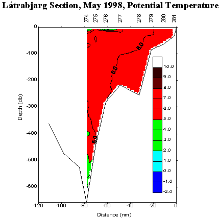
The main result of the hydrographic observations in Icelandic waters in Spring (May-June) 1998 were the following (see e.g. Fig. 13a , Fig. 13b , Fig. 14a , and Fig. 14b ):
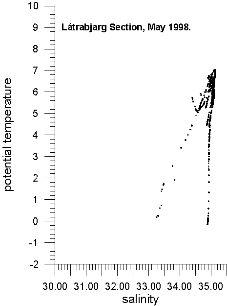
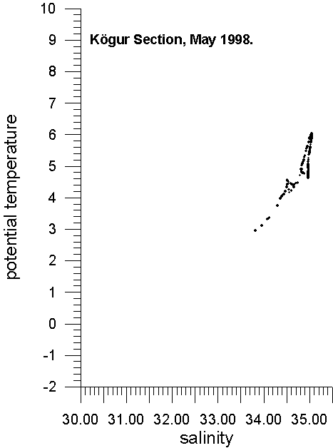
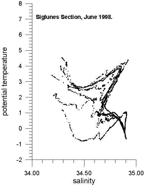
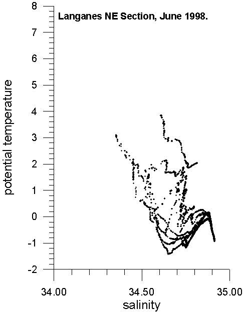
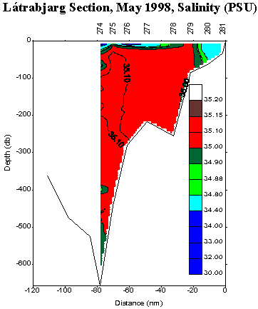
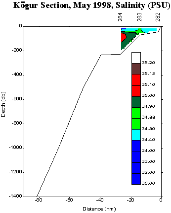
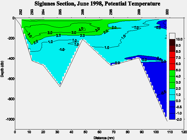
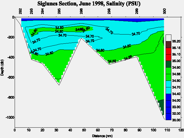
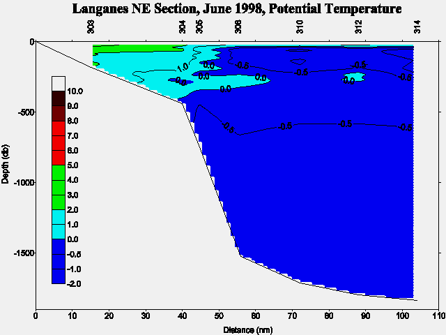
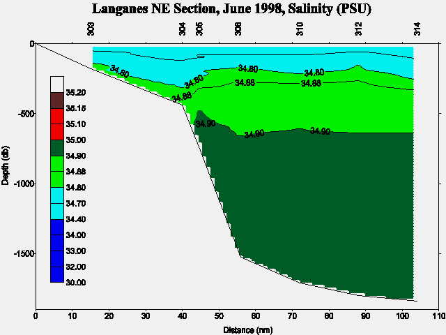
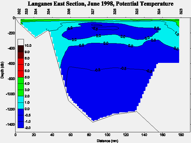
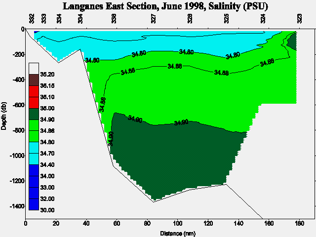
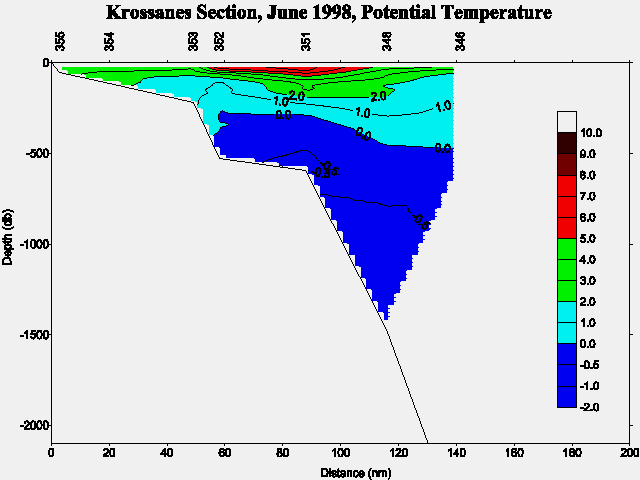
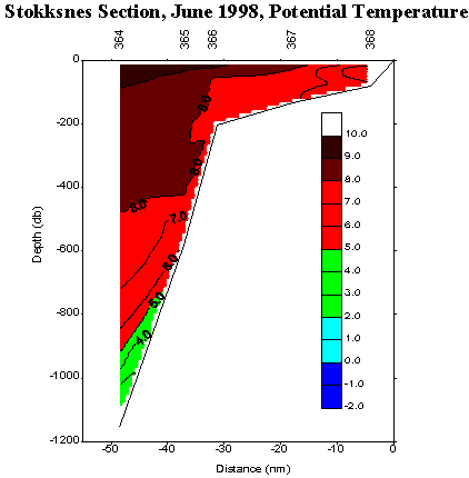
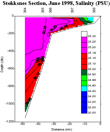
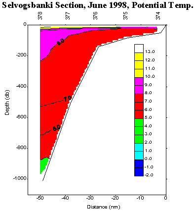
The Atlantic Water (Irminger Current) south and west of Iceland showed high temperatures (7-8°C) as well as salinities (35.00-35.25). These conditions are in continuity of findings from 1997 which reveal higher values than ever found since the early sixties. These conditions seem not to have had an input on the inflow of Atlantic Water into North Icelandic waters, but rather westwards into the Irminger Sea towards Greenland. The inflow into North Icelandic waters was quit modest (3-5°C, 34.8-35.0) and like in 1997 covered with a relatively cold low saline surface layer (<34.4) in accordance with rather frequent relatively heavy drift ice conditions in North Icelandic waters in winter and spring 1998. Farther off at the shelf break in North Icelandic waters the cold (0-2°C) Polar/Arctic Water was found as usual. East of Iceland temperatures were 2-3°C or 1°C higher than at the same time in 1997, but the salinity was similar (34.6-34.7), and farther off the cold East Icelandic Current showed - up to be rather weak both in hydrographic conditions and in extension southeastwards, results comparative with findings earlier in the year (February/March).
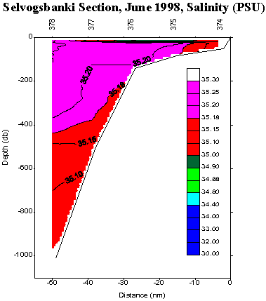
At the boundaries between the cold and warm waters off the east coast the warm water input was relatively strong (>8°C, >35.2) and the warm Atlantic water off the south coast was found quite near-shore, but covered with a thin surface run-off layer (~10m) in accordance with extreme calm weather conditions during the cruise.
Nutrient content, primary production and zooplankton concentrations were as usual dependent on each other, but on different stages in different areas. The zooplankton concentration was in general near or above average. Thus from a biological point of view the overall conditions were in general favorable. Also it should be stated that the Atlanto-Scandian herring migrated farther westward in the Norwegian Sea than in previous year, which seems to be in accordance with the hydro-biological findings in the East Icelandic Current.
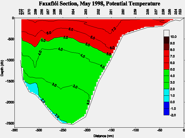
The overall results of interest for the VEINS are a) relatively unfavorable drift ice conditions in the Denmark Strait area and even eastwards on the outer shelf in North Icelandic waters prior to the cruise, b) as well as a relative weak transport of fresh water from the north within the East Icelandic Current, and c) a strong input of Atlantic water from south of Iceland. The cold "overflow" along the East Greenland continental slope (Figure 3a) showed potential temperatures below 2°C in the depth range of 1400-2500 m similar as in February 1998, but no indication of "low" saline water (Polar Intermediate Water) above as in February.
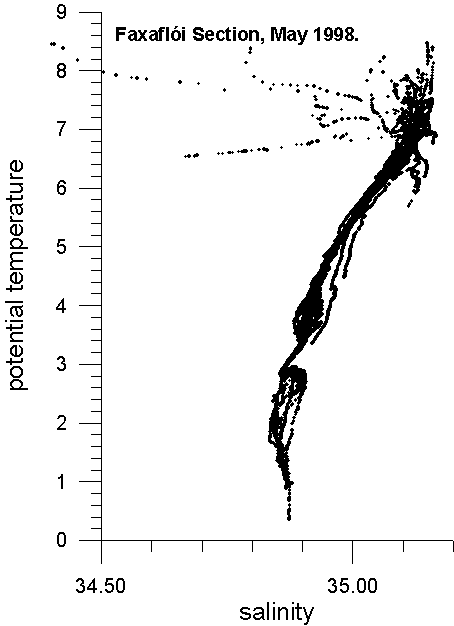
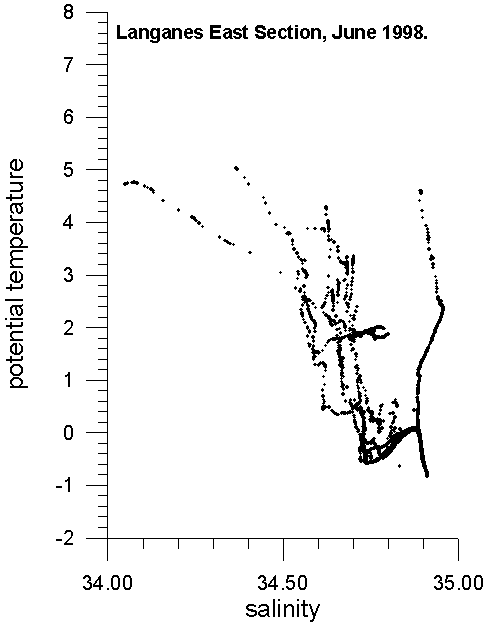
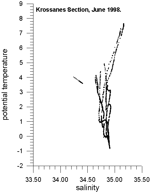
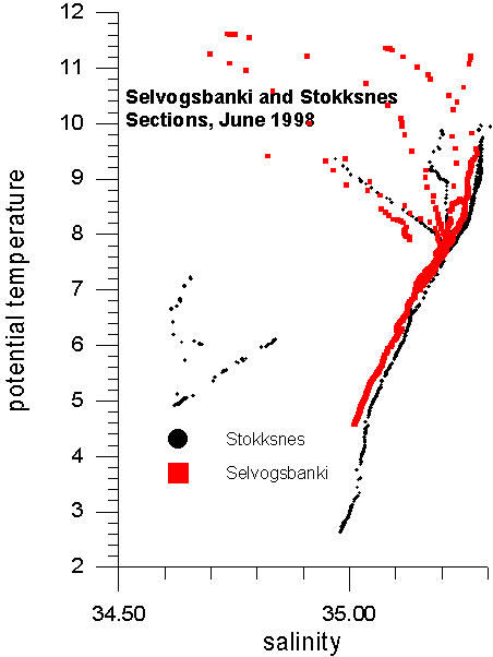
Preliminary TS-diagrams from the Faxaflói , Látrabjarg , Kögur , Siglunes , Langanes NE , Langanes E , Krossanes , Stokksnes and Selvogsbanki sections show the results above. In addition are preliminary potential temperature and salinity sections shown for Faxaflói (Fig. 3a and Fig. 3b), Látrabjarg (Fig. 4a and Fig. 4b), Kögur (Fig. 5a and Fig. 5b), Siglunes (Fig. 6a and Fig. 6b), Langanes NE (Fig. 7a and Fig. 7b), Langanes E (Fig. 8a and Fig. 8b), Krossanes (Fig. 9a and Fig. 9b), Stokksnes (Fig. 10a and Fig. 10b) and Selvogsbanki (Fig. 11a and Fig. 11b) sections respectively, of which Figure 3, 4, 5, 7 and 9 are part of the VEINS programme.
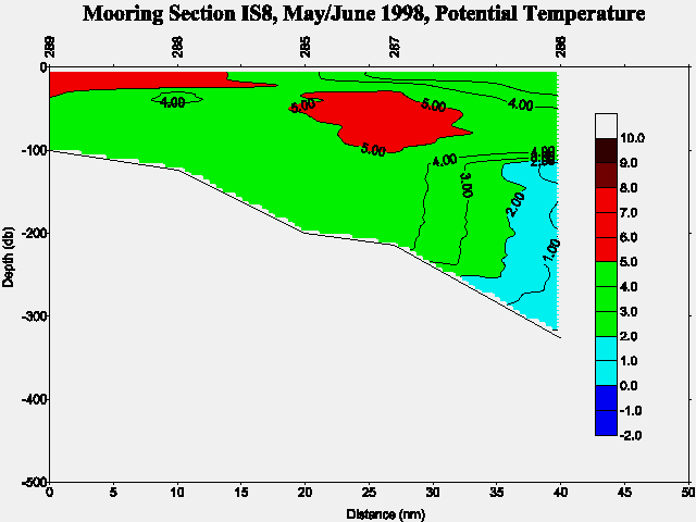
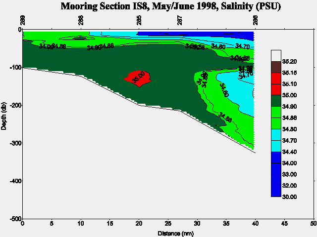
Another potential temperature and salinity sections have been included in this report showing the Mooring Section IS8 (Fig. 12a and Fig. 12b). For location of the above sections see Figure 1 and the station numbers.
In case of further information contact:
| Dr. Svend-Aage Malmberg | Email: | svam@hafro.is |
| Mr. Jóhannes Briem | Email: | briem@hafro.is |
| Mr. Héðinn Valdimarsson | Email: | hv@hafro.is |
| Dr. John Mortensen | Email: | johnm@hafro.is |
or by mail:
Att. nameor
Tel. (+354) 55 20240
Fax. (+354) 56 23790
| © MRI | Back to Cruise Reports | ||
|
|
|||
| Responsible: John Mortensen | MRI | ||