Departure: Reykjavík, Iceland, November 27th 1997
Arrival: Reykjavík, Iceland, December 14th 1997
Jóhannes Briem, Chief Scientist
John Mortensen, Physical Oceanography
Magnús Danielsen, Chemical Oceanography
Björn Sigurðarsson, Physical Oceanography
Jón Ólafsson, Chemical Oceanography
The B15-97 cruise was carried out by the Marine Research Institute (MRI) on the RV Bjarni Sæmundsson with the following aims:
The RV Bjarni Sæmundsson left Reykjavík just before midnight on the 27th of November 1997. After the 1st station on the Faxaflói section the ship had to return to harbor because of minor engine trouble departing again at 1600 hours.
After seven stations of the Faxaflói section deploying two satellite tracked drifters at stations 678 and 680, the ship headed for the Kögur section and the IS-8 current meter mooring in order to take advantage of favorable ice conditions in the northern Denmark Strait. Having covered the Kögur section out to the ice edge, with ESOP-II sampling at stations 688, 689 and 690, serviced the mooring and taken the Látrabjarg section from the coast out to the ice, the course was set for the western end of the Faxaflói section. Two meteorological drift buoys were deployed on this section at stations 708 and 716.
Changing weather conditions called for a southerly course anticlockwise around Iceland where the following sections were covered and drifters deployed at stations 720, 721, 724, 727, 728 and 729: Selvogsbanki, Stokksnes, Krossanes, Langanes E, Langanes NE with ESOP-II sampling at stations 751 and 753, Slétta, Siglunes with ESOP-II sampling at station 769 and Húnaflói. The ship arrived in Reykjavík at 1000 hours on the 14th of December in a rising southeasterly gale having sailed 3058 nm.
Sections confined to VEINS are those of Faxaflói, Látrabjarg, Kögur, Langanes NE and Krossanes. Locations where surface drifters were deployed (indicated by o) are shown in Figure 1 as well as locations of current meter moorings (indicated by m) in VEINS tasks 1.4.1, 1.4.3. and 1.4.4.
The hydrographic work was carried out with two independent CTD-water sampling units both equipped with Seabird Inc. SBE 911plus CTD's. The first unit, a MRI made rosette equipped with 12 modified Hydro-Bios 1.7 liter water bottles and a General Oceanics underwater unit, was used for all standard CTD stations. The other unit (referred to as Unit B) comprised of SBE 32 rosette equipped with 12 Go-Flo 8 liter water samplers was used for chemical sampling on ESOP-2 stations. A Sea-Tec transmissometer was attached to the MRI unit. Both units were equipped with newly calibrated temperature and conductivity sensors and water samples were collected at deepest sampling level on all stations for calibration purposes.
	    Temp. Calibr.  Cond. Calibr.
	   sensor date    sensor date

Unit A       2021 14-08-97  1643 15-08-97
Unit B       1172 29-08-97   861 27-08-97
Samples for oxygen measurements were collected in 60 ml bottles,
and Winkler reagents added. Samples were then placed in a dark cold storage until the time of
analysis. Oxygen concentration was determined using a modified Winkler method.
Samples for nutrient analysis, nitrate, phosphate and silicate, were collected on selected
stations, in 250 ml polyethylene bottles. Samples were freezed, for later analysis in land
on a ChemLab auto-analyzer.
Samples for pCO2 and total carbonate were collected on 7 stations
in 500 and 250 ml bottles, preserved with mercury chloride and placed in cold storage.
Samples for delta carbon-13 were collected from the surface at 7 stations and a full
profile was collected from 2 stations. The samples were preserved with mercury chloride.
Samples for sulfur-hexafluoride (SF6) were collected at 6 stations in 500 ml bottles supplied
by the University of East Anglia and placed in cold storage.
Samples for iodine-129 profile were collected at 2 stations in 1 liter polyethylene bottles
supplied by Centre de Spectrometrie Nucleaire et de Specrometrie de Masse.
During the B15-97 cruise the following current meter mooring was serviced and deployed (VEINS tasks 1.4.4).
St.id.	     Position       Water Instr. Type           Serial  Date    Notes
	Lat.	  Lon.	    depth depth			no.
IS-8    67 00.00N 21 35.00W  199    74   Aanderaa RCM7  11986   301197  recovered
IS-8    67 00.00N 21 35.00W  199   149   Aanderaa RCM7  10585   301197  recovered
IS-8    67 00.00N 21 35.00W  199    75   Aanderaa RCM7   6934   301197  deployed
IS-8    67 00.00N 21 35.00W  199   150   Aanderaa RCM7   7332   301197  deployed
All the goals of the cruise were achieved (see list of stations and cruise track-Figure 1) except that a second attempt to service the current meter mooring (IS6) on the Kögur section failed due to ice conditions. Instead the current meter mooring (IS8) east of Kögur section was serviced (for positions see Figure 1). Moorings are indicated by m and station id.
Click your way through the cruise track
, i.e. by clicking in the left or right part of the section name you will get potential temperature or
salinity sections of the section respectively.
The main results of the hydrographic observations in Icelandic waters in November-December 1997 were the following:
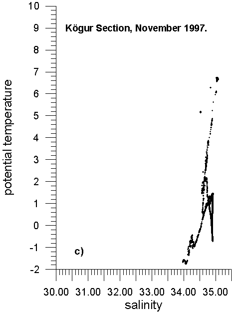
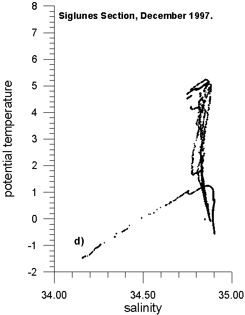
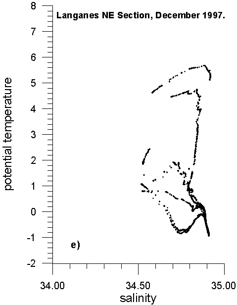
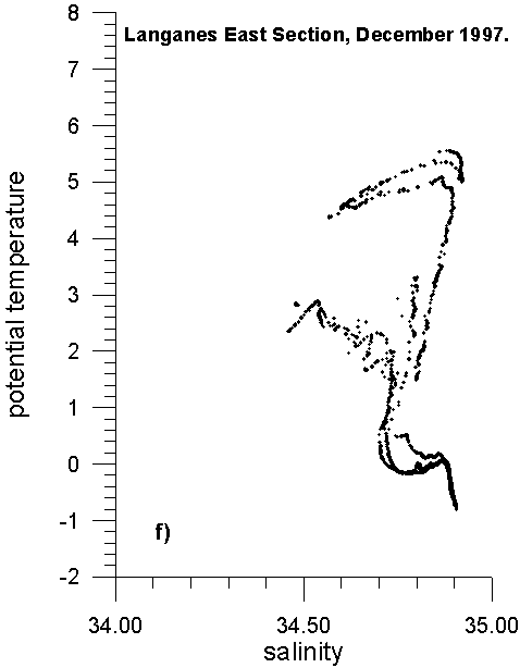
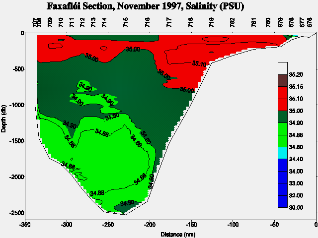
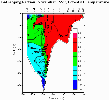
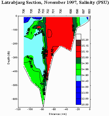
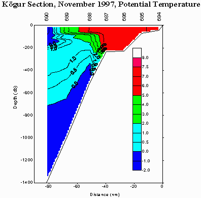
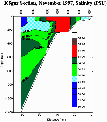
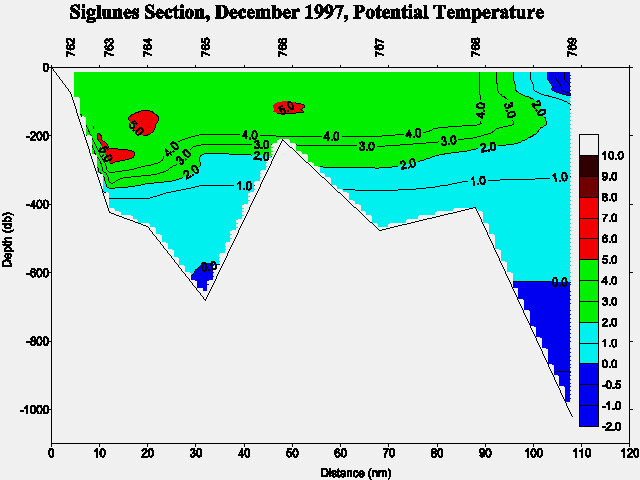
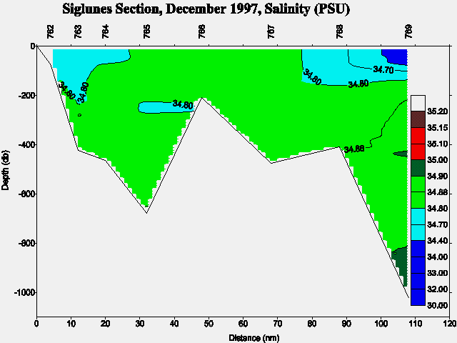
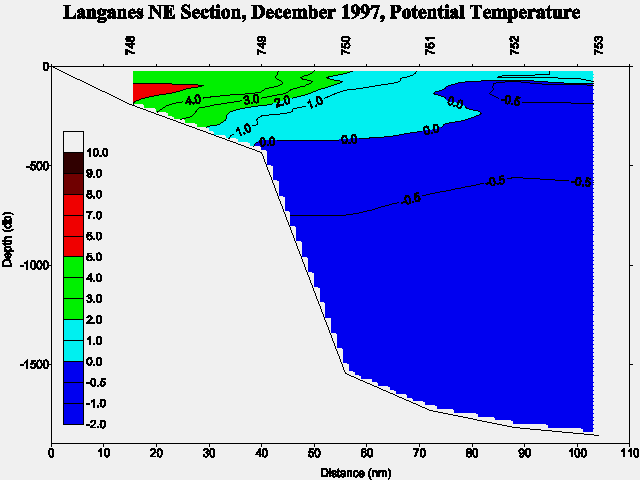
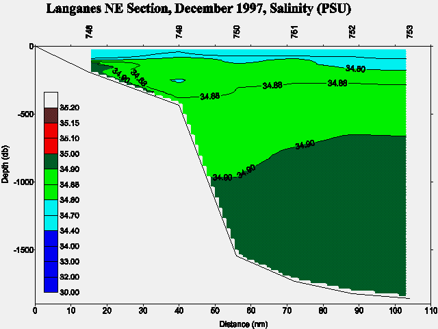
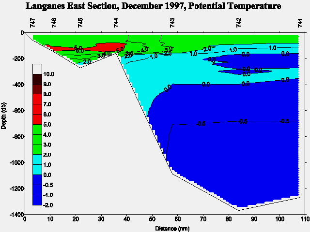
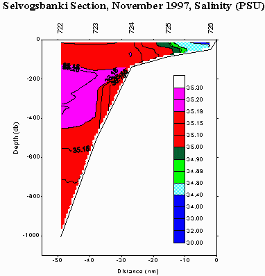
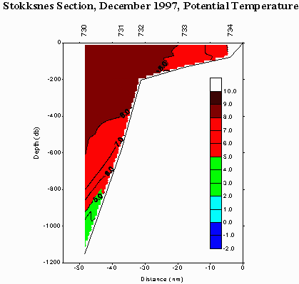
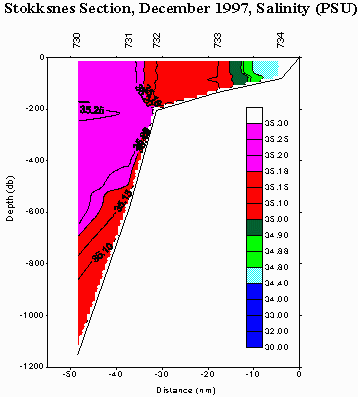
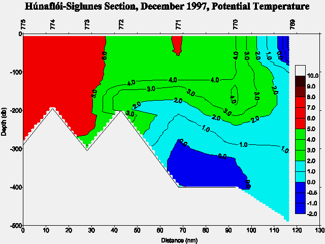
The Atlantic Water (the Irminger Current) south and west of Iceland showed high temperatures (8-9°C) and salinities (up to and above 35.2), the salinities being in accordance with earlier observations in year 1997 which were higher than during the previous years. The inflow of Atlantic Water into North Icelandic Waters was also quite pronounced (6-7°C, S>35.0) and reached almost as far east as to Siglunes (4-5°C) and even farther eastwards with decreasing temperatures and salinities in direction to winter conditions. East of Iceland temperatures too were relatively high (2-4°C) and the salinity was around 34.7-34.8. The cold tongue of the East Icelandic Current northeast of Iceland with temperatures below 0°C and salinities of 34.6-34.8 had moved farther north- and northeastwards since August-September. Thus the hydrographic conditions in Icelandic Waters were quite favorable in November-December 1997.
The overall results of interest for the VEINS project are a pronounced inflow of warm and saline Atlantic Water north through the Denmark Strait and a relatively weak transport of fresh water from north with the East Icelandic Current. The cold "overflow" along the East Greenland continental slope (Figure 3a) showed potential temperatures of 1-2°C and even with values slightly below 1°C below 1500 m on the Faxaflói section.
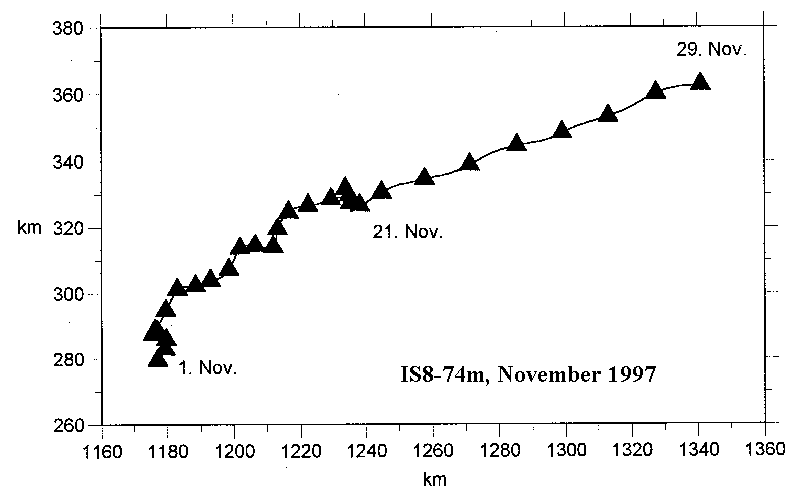
At last it may be noted that just prior to the cruise in November prolonged periods of northerly winds occurred, with frequent gales in the Denmark Strait and Iceland Sea. A preliminary progressive vector diagram of the current from 74 m depth at mooring IS8 in November 1997 shows a possible influence of the wind conditions on the inflow of Atlantic Water into North Icelandic Waters. As seen in the figure the easterly inflow increased around Nov. 21th from about 0.06 m/s to about 0.16 m/s.
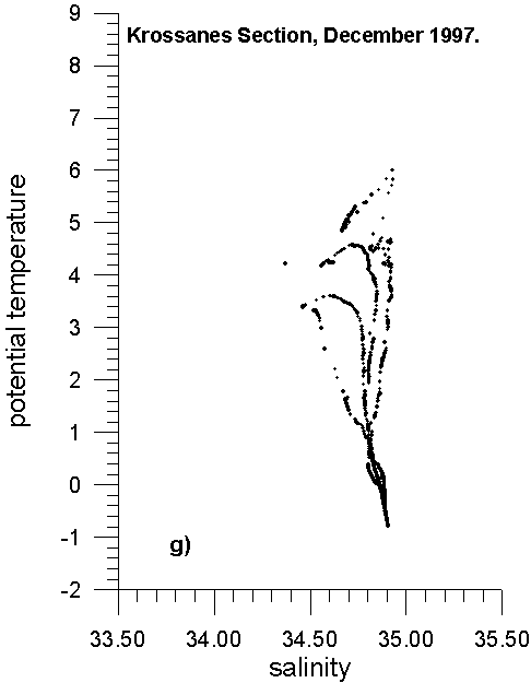
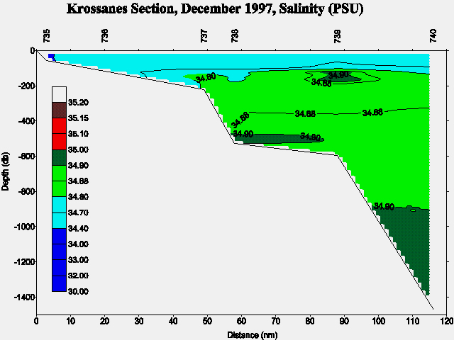
Preliminary TS-diagrams from the Faxaflói , Látrabjarg , Kögur , Siglunes , Langanes NE , Langanes E , Krossanes and Selvogsbanki/Stokksnes sections show the above results. In addition are preliminary potential temperature and salinity sections shown for Faxaflói (Fig. 3a and Fig. 3b), Látrabjarg (Fig. 4a and Fig. 4b), Kögur (Fig. 5a and Fig. 5b), Siglunes (Fig. 6a and Fig. 6b), Langanes NE (Fig. 7a and Fig. 7b), Langanes E (Fig. 8a and Fig. 8b), Krossanes (Fig. 9a and Fig. 9b), Selvogsbanki (Fig. 10a and Fig. 10b), and Stokksnes (Fig. 11a and Fig. 11b) sections respectively, of which Figure 3, 4, 5, 7 and 9 are part of the VEINS programme.
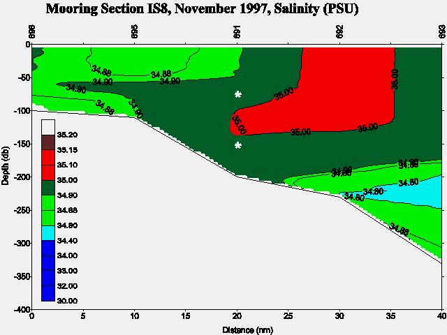
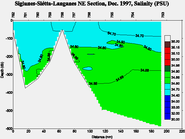
Three other potential temperature and salinity sections have been included in this report showing: Mooring Section IS8 (Fig. 12a and Fig. 12b), including the location of the current meters. Húnaflói-Siglunes section (Fig. 13a and Fig. 13b), and Siglunes-Slétta-Langanes NE Section (Fig. 14a and Fig. 14b). Note that the two latter sections are composed of a number of line segments (see Figure 1 and the stations numbers).
In case of further information contact:
| Dr. Svend-Aage Malmberg | Email: | svam@hafro.is |
| Mr. Jóhannes Briem | Email: | briem@hafro.is |
| Mr. Héðinn Valdimarsson | Email: | hv@hafro.is |
| Dr. John Mortensen | Email: | johnm@hafro.is |
or by mail:
Att. nameor
Tel. (+354) 55 20240
Fax. (+354) 56 23790
| © MRI | Back to Cruise Reports | ||
|
|
|||
| Responsible: John Mortensen | MRI | ||